


Name:
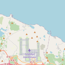
LTFM
Station ID:
646168
Source:
Symbol:
 Weather Station
Latest Packet:
Status Packet
Receive Time:
03/14/2025 8:17:41 PM+00:00
Age:
5 minutes ago
Path:
APRS,TCPIP*,qAS,TA7HBK-1
Comment:
İstanbul Havalimanı için rasat verileri ile oluşturulmuştur. İletişim TA7HBK.
Latest Weather:
03/14/2025 8:17:41 PM+00:00
Comment/Software:
LTFM 141950Z 22010KT CAVOK 16/09 Q1017 NOSIG RMK RWY17L 22014KT RWY34L 21006KT RWY16R 21008KT RWY36 23012KT RWY18 23016KT TAF LTFM 141640Z 1418/1524 21014KT CAVOK BECMG 1500/1503 21017G27KT BECMG 1514/1517 20015KT
Latest Position:
41.2575, 28.73317
Receive Time:
03/14/2025 8:17:41 PM+00:00
Speed:
20.37 km/h
Course:
220°
Packet frequency:
804s (Latest 12 packets)


- The specified "Station ID" is the ID that this station has on this website, this ID is useful when creating a link to this website. Read more in the About/FAQ.
- To get a better understanding of the APRS path I recommend reading the explanation written by wa8lmf.
- If this packet has the "Posambiguity"-mark it means that the sent position is ambiguous (a configured number of digits has been truncated from the end of the position).
- PHG stands for Power-Height-Gain (and directivity). The height is not the height above sea-level, it is the height above average terrain (HAAT = Height Above Average Terrain). PHG is used to calculate the relative RF range of a station. If this station has reported several positions or symbols the PHG data will only be used for the position and symbol used in the PHG-packet.
- RNG is the "pre-calculated omni-directional radio range" of the station (reported by the station itself). If this station has reported several positions or symbols the RNG data will only be used for the position and symbol used in the RNG-packet. It seems like many D-STAR station use the RNG value to specifify D-STAR range.
- One object may be sent by several different senders. On the map they may share the same path, but they all have their own "Station information" modal.
- If station has more than 15 related stations we will only show the 10 closest related stations.